Article 1 - FTG Budgell Harbour Stock
Contributed by McMaster University - No 1 of 3 articles

Chibuike Nnadi - Applied Geophysicist. Student at McMaster University

Alexander L. Peace - Assistant Professor at McMaster University
Article 1 - Introduction to FTG data and its application to the Budgell Harbour Stock prospect, Newfoundland, Canada
Acknowledgements - This blog post and the others in this series are primarily based on previously published work (Geng et al., 2018, 2019b, 2019a, 2020; Peace et al., 2018a, 2018b). In addition, the authors would like to highlight the contributions of Meixia Geng, J. Kim Welford and Colin Farquharson to this work, as well as thank the Geological Survey of Newfoundland and Labrador for assisting with access to the Bell Geospace Ltd. FTG data. The various undergraduate field assistants that contributed to this work are also gratefully acknowledged.
Introduction
This will be the first of a series of blog posts on the Budgell Harbour Stock (BHS), an intrusive gabbroic rock in Newfoundland in Eastern Canada that is of economic interest due to its potential to host platinum group mineralization. These blog posts are entirely based on previously published materials (see acknowledgements and references) that utilised the Full Tensor Gradiometry (FTG) data obtained by Bell Geospace Ltd. in this area.
A brief overview of the regional geology, the principles of Full Tensor Gradiometry (FTG) and the data acquisition will be covered in this blog post. In the next two posts, we will examine the 3-D inversion and modelling of the FTG data from the Budgell Harbour Stock, Newfoundland, Canada, and also look at how the surface and subsurface observations were integrated through the FTG data.


Regional geology and study location
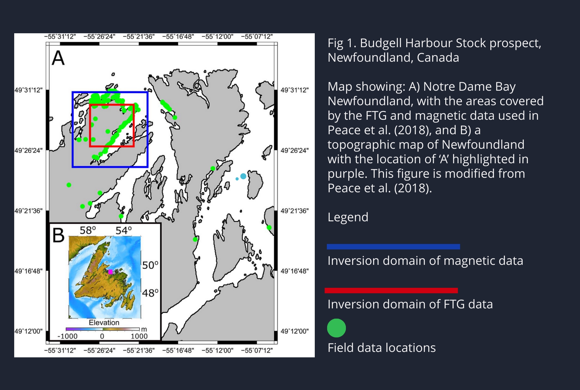
The BHS is located in Newfoundland, an island off the east coast of Canada (Fig 1). This intrusion is likely Jurassic in age and intrudes older sediments. Its intrusion has been linked to the stretching that occurred before the Atlantic Ocean opened (Peace et al., 2018a). However, much remains to be determined regarding its structure, largely due to poor surface exposure, highlighting the need for exploration using geophysical approaches.
In terms of composition, BHS is largely gabbroic and is a mineral prospect for platinum group elements (copper, nickel, cobalt, etc., Strong and Harris, 1974). It is for this latter reason that the high-resolution FTG data were collected in this area.
What are FTG data and how are these data acquired?
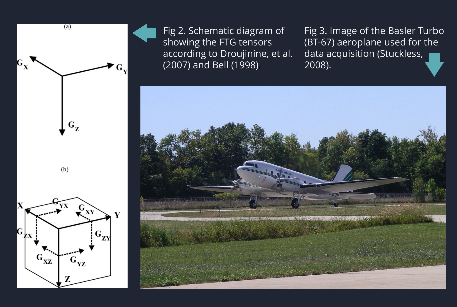
FTG measures the acceleration due to gravity and all the gravity field components (Fig 2) using a high precision multiple accelerometer system which is composed of three gravity gradient instruments (GGIs). FTG has a very high accuracy and resolution and is therefore widely applied in mineral exploration where detailed knowledge of the subsurface can have big economic implications!
The FTG data for the BHS was acquired by Bell Geospace in 2007 using an FTG system mounted on a Basler Turbo BT-67 (Fig 3) for solid mineral prospecting and to determine possible drill hole locations. The FTG methodology was very applicable in this study due to the density contrast caused by this prospective body and the surrounding rocks which results in the BHS producing a high-density anomaly on the data.
In the next article we will look in more detail at the actual FTG data from the BHS prospect, including 3D inversion of this data.
References
Bell, R.E., 1998. Gravity gradiometry, Scientific American, vol. 278, No. 6, pp. 74-79.
Droujinine, A., Vasilevsky, A., and Evans, R., 2007, Feasibility of using full tensor gradient (FTG) data for detection of local lateral density contrasts during reservoir monitoring: Geophysical Journal International, v. 169, p. 795-820, doi:10.1111/j.1365-246X.2007.02806x.
Geng, M., Farquharson, C.G., Welford, J.K., Peace, A.L., Farquharson, C.G., and Peace, A.L., 2019a, 3-D inversion of airborne gravity gradiometry data for the Budgell Harbour Stock, Newfoundland: A case history using a probabilistic approach: Geophysics, doi:10.1190/segam2018-2978510.1.
Geng, M., Welford, J.K., Farquharson, C.G., and Peace, A.L., 2018, 3-D inversion of airborne gravity gradiometry data for the Budgell Harbour Stock: A case history of using a probabilistic approach, in Society of Exploration Geophysicists (SEG) October 14th-19th 2018, Anaheim, Ca, USA, doi:10.1190/segam2018-2978510.1.
Geng, M., Welford, J.K., Farquharson, C.G., and Peace, A.L., 2019b, 3D joint inversion of airborne gravity gradiometry and magnetic data : A case study, in Society of Exploration Geophysicists (SEG) 15th-20th of September, San Antonio, TX, USA, doi:https://doi.org/10.1190/segam2019-3208039.1.
Geng, M., Welford, J.K., Farquharson, C.G., Peace, A.L., and Hu, X., 2020, 3-D joint inversion of airborne gravity gradiometry and magnetic data using a probabilistic method: Geophysical Journal International, v. 223, p. 301–322, doi:10.1093/gji/ggaa283.
Peace, A.L., Welford, J.K., Geng, M., Sandeman, H., Gaetz, B.D., and Ryan, S.S., 2018a, Rift-related magmatism on magma-poor margins: Structural and potential-field analyses of the Mesozoic Notre Dame Bay intrusions, Newfoundland, Canada and their link to North Atlantic Opening: Tectonophysics, v. 745, p. 24–45, doi:10.1016/j.tecto.2018.07.025.
Peace, A.L., Welford, J.K., Geng, M., Sandeman, H., Gaetz, B.D., and Ryan, S.S., 2018b, Structural geology data and 3-D subsurface models of the Budgell Harbour Stock and associated dykes, Newfoundland, Canada: Data in Brief, p. 1–7, doi:10.1016/j.dib.2018.10.072.
Strong, D.F., and Harris, A., 1974, The Petrology of Mesozoic Alkaline Intrusives of Central Newfoundland: Canadian Journal of Earth Sciences, v. 11, p. 1208–1219, doi:10.1139/e74-114.
Stuckless, E., 2008, Celtic Minerals Assessment Report discussing Geochemistry, Geophysics, and Diamond Drilling on the Budgell’s Harbour Property, Central Newfoundland
Receive Bell Geospace Articles To Your Inbox
Would you like to receive the next installment directly to your email?
